Your Say Northern Beaches

Menu
  • Home
  • All Projects
  • Login
  • Sign up
  • Login / Join
  • My profile
    • Edit profile
    • Sign out
  • Search this site...

Frenchs Forest Active Transport Network

Building better connections

You are here:

  1. Home
  2. Frenchs Forest Active Transport Network
Image of NSW govt logo

Proudly funded by the NSW Government

Project update: March 2025

With $3.1 million from the NSW Government, we are delivering the Active Travel Plan in two stages. To make the best use of the funding, we have phased the project, prioritising connections to schools and shopping precincts. This approach allows us to prioritise safety while staying within budget.

Since the initial community consultation, we have refined the Stage 1 designs based on your feedback. The updated designs, along with the Community Engagement Report, were presented to the Local Traffic Committee, which approved the crossing facilities at its meeting on 4 February 2025.

Stage 1 of the Active Travel Plan includes:

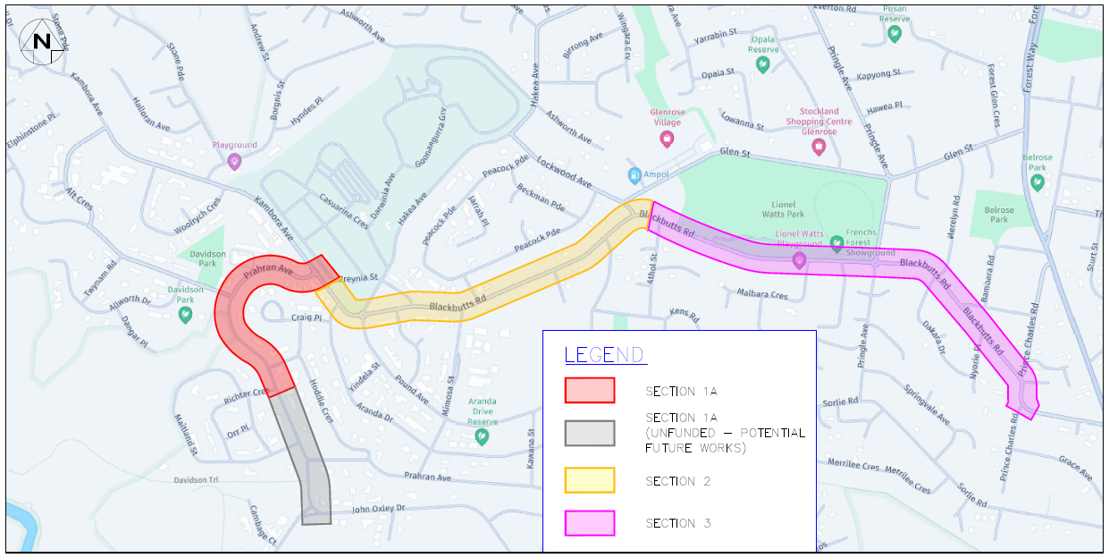
  • sections 2 and 3 of the plan, with either 1a or 1b to follow, depending on funding availability
  • a 2.5m-wide shared-user path along Blackbutts Road and Kambora Avenue, linking Lionel Watts and Prahran Avenue
  • improved access to key locations including Glen Street Theatre & Library, Glenrose Village, Frenchs Forest Showground, and Lionel Watts Reserve
  • the upgrades will also enhance connections to Mimosa Public School, Davidson High School and Wakehurst Public School.


What's next?

We are now preparing the detailed designs for Stage 1 program of works, which we will be available shortly. We will provide further updates once the exhibition timeline is confirmed.

We are seeking additional funding to complete Stage 2 of the Active Travel Plan and will inform you when funding becomes available.

View Stage 1 program of works open in new window
View Stage 2 program of works (subject to funding) open in new window

Project background

Project background

We are improving transport options for short local trips and recreation across Beacon Hill, Frenchs Forest, and Davidson by making it easier and safer for people walking and bike riding, in line with our adopted Northern Beaches Transport Strategy 2038.

The new shared-user path network will stretch 7.7km from Beacon Hill to Davidson, featuring new connections and upgrades to existing paths. This plan will link key destinations in the neighbourhood, transforming community access to local schools, shopping centres, recreational facilities, and other amenities.

We want to provide safer routes that are primarily separated from vehicular traffic or situated on quieter streets, with a strong focus on families and children travelling to and from school. The proposal also includes 26 new and upgraded raised crossing facilities and reduced speed limits on some quiet residential streets to improve safety for everyone using the road.

  • Why are we doing this?

    • Safer trips to schools, shops, and parks
    • Encouraging healthier, active lifestyles
    • Reducing reliance on cars
    • Building a more connected community
    • Supporting our long-term transport vision

    Read more about our Transport Strategy 

  • Key benefits

    • Transport for everyone, anytime
    • Safe and comfortable travel
    • Family-friendly routes
    • Easy access to local destinations and public transport
    • Boost your health and fitness
    • Less traffic, cleaner air
    • Eco-friendly and cost-effective options
  • What will be improved?

    • 6km of new shared walking and bike paths
    • Upgrades to existing paths
    • 18 new and 8 upgraded raised crossing facilities for enhanced safety
    • Reduced speed limits on select quiet residential streets
    • Route connects 7 local schools

    Click here for a full section breakdown 

View the plan

View the plan

Get up close and personal with your future community landscape. The plan gives an overview of the proposed works.
Overview of works
Overview of works
Sections 1 & 2
Sections 1 & 2
Sections 3 & 4
Sections 3 & 4
Section 5
Section 5
Sections 6 & 7
Sections 6 & 7
Download the plan open in new window

Community engagement

We exhibited the plan between 20 September to 20 October 2024 and received a high level of support from our community for active transport in the area. Those who responded cited the anticipated benefits for residents by making walking and bike riding in their local neighbourhood an easier and safer transport option. Read the Community Engagement Report for more details.

The new or upgraded priority crossings across sections 1a, 1b, 2 and 3 of the project, along with the Community Engagement Report were presented to Council's Local Traffic Committee for approval.

The Local Traffic Committee approved the plans at its meeting on 4 February 2025 (item 4.1):

  • View the Agenda
  • View the Minutes

Your feedback was used to refine the detailed design for Stage 1 of works, which will soon be available for public exhibition.

Read the Community Engagement Report open in new window

Funding and FAQs

Image of  NSW govt logo

Proudly funded by the NSW Government

  • How is the project funded?
  • When will construction begin?

FAQ

  • How is the project funded?
  • Stage 1 of works is proudly funded by the NSW Government through the Public Spaces Legacy Program and Places to Roam Program.

    We are seeking additional funding to complete Stage 2 of works.

  • When will construction begin?
  • Stage 1 construction is anticipated to begin mid 2025, subject to the outcomes of Stage 2 community consultation, approvals, contractor availability and weather.

    Stage 1 will occur in phases over 6 months, weather permitting.

  • What are the potential impacts during construction?
  • We understand the difficulty of completing work without causing disruptions, especially during bad weather. We will work closely with the contractors to minimise temporary impacts on traffic, pedestrians, noise, and dust.

    To minimise traffic impacts during the day, some operations will be scheduled for nighttime. We will notify neighbouring properties before night work takes place.

    Residents along the corridor will receive direct communication from the contractors with additional details prior to the commencement of any work.

Project overview

  • What is a shared-user path and why was it chosen for this project?
  • A shared-user path is a public path designated for the use of people walking and bike riding. Shared-user paths can be identified by signage and/or pavement markings showing a pedestrian and a bike.

    We have carefully considered different types of infrastructure in the planning of this project. Shared-user paths are generally suited to routes that provide local links with low walking and/or cycling volumes and accommodate slower speed riding separated from vehicular traffic. Whilst separated footpaths and bike paths tend to be the preferred type of infrastructure, in this instance, a shared-user path was chosen because of the nature of the selected route, constructability considerations and funding constraints.

    Shared-user paths are common across the Northern Beaches, recent examples include Warringah Road, Frenchs Forest and Forest Way, Belrose. These paths make it easier and safer for people walking and bike riding, providing improved transport options for short local trips and recreation.

    We recognise the increasing popularity of e-bikes which is making cycling a more accessible option for a wider range of trips and people of all ages and abilities. This has been considered in the design by ensuring a sufficient width of 2.5m where possible along the route.

    Beyond this project, we will continue to actively work on planning and delivering new separated bike paths across our key regional routes in the Northern Beaches.

  • How was the route selected and what information informed the design?
  • This route was selected to improve connectivity throughout Beacon Hill, Frenchs Forest and Davidson, to maintain the key objective of the Pipeline Active Transport Corridor project which is no longer able to proceed.

    This selected route was informed by our adopted Northern Beaches Bike Plan and will connect to a range of key local destinations including 7 schools and Frenchs Forest Town Centre.

    The design and route have been informed by extensive analysis including:

    • desktop road and footpath measurements
    • related Council and NSW Government plans such as the Move – Northern Beaches Transport Strategy 2038
    • Frenchs Forest 2041 Place Strategy and Hospital Precinct Structure Plan
    • Australian Standards and technical guidelines such as the Transport for NSW Cycleway Design Toolbox
    • constraints in the study area
    • site inspections.
  • What is a quietway?
  • A quietway is a high-quality, low-speed mixed-traffic environment where bicycle riders travel with vehicular traffic in the centre of the traffic lane. This will be implemented in Dareen Street in Beacon Hill between the cul-de-sac and Jones Street as well as Akora Road in Frenchs Forest.

  • What amenities and transport connections will be available?
  • This route will connect residents of Davidson and Beacon Hill with the proposed Frenchs Forest Town Centre and the new Frenchs Forest High School along with improving access to existing shops and primary schools.

    This route will provide links to existing shared paths which connect to Allambie Heights, Narraweena and Dee Why. This project will also improve connections for people joining frequent bus services towards Dee Why, Chatswood and the City from Forestway Shopping Centre.

    Davidson, Frenchs Forest and Beacon Hill have high rates of car ownership, so improving transport infrastructure will give more transport options for residents to help achieve our mode shift aspirations in our MOVE Transport Strategy and reduce transport emissions.

    Wayfinding signage and bike parking will be provided along the corridor. We will seek opportunities to provide bike maintenance stands, water fountains and seating along the route, subject to available funding.

  • What are the project's impacts on car parking, trees, and street speed limits?
  • There will be minimal impact to on-street parking as the shared-user path will be built along the road reserve. However, to ensure safer intersections and adequate sight lines, there will be some localised reductions in on-street parking immediately around the new pedestrian crossings as per statutory requirements.

    We recognise the importance of street trees as part of our local environment and in providing green, leafy and shady places. Tree canopy was one of the considerations in planning the route alignment, with preference for the side of the street that will maximise retention of valuable and mature trees. Where possible, we will work around existing trees with pinch points to minimse impacts on trees. There may also be some localised tree trimming to ensure sufficient height clearance along the path. As per our adopted Tree Canopy Plan, a minimum of 2 trees will be planted for any 1 tree removed from public land. We intend for any replanting to occur directly along the project route, including through tree pits in the shared-user path where space allows to provide a shady path for people walking and bike riding.

    As part of this project, 2 low-volume local residential streets will be upgraded to a 20km/h quietway to improve safety and network connectivity. A quietway is a high-quality low-speed mixed traffic environment where bicycle riders travel with vehicular traffic in the centre of the traffic lane. This will be implemented in Dareen Street in Beacon Hill between the cul-de-sac and Jones Street and Akora Road in Frenchs Forest.

  • What happened to the Pipeline Active Transport Corridor?
  • The Pipeline Active Transport Project will not be proceeding as originally proposed by Council.

    As planning progressed, the original intended route was found to be less suitable than anticipated, impacting the project’s feasibility.

    We are committed to the original goal of enhancing active transport options in the area, a revised project route has been developed to continue improving connectivity and safety for people walking and bike riding in Beacon Hill, Frenchs Forest and Davidson.

Project timeline and construction

Using the shared path

  • What are the rules and safety considerations for path users?
  • On shared-user paths, people riding bicycles, skateboards, foot scooters and rollerblades must:

    • keep to the left (unless it’s not practical).
    • give way to pedestrians. This means slowing down and even coming to a stop if necessary.
    • keep to the left of any oncoming pedestrian or bike rider.

    Bike riders are advised to:

    • try and provide one metre of space when overtaking.
    • travel at a speed in accordance with your surroundings. Shared-user paths often have many young children, dogs and older pedestrians that bike riders will need to be aware of. Often their movements can be unpredictable, and you may need to stop in a hurry.
    • use your bell or politely call out “Overtaking on the left/right” to let pedestrians know you are there.

    Pedestrians are advised to:

    • keep left unless overtaking
    • be aware of surroundings such as dogs, children and bike riders.
    • if you are planning to stop, we suggest moving off the path to your left.
    • keep animals on short leads so you can react to any hazards accordingly. Often leads can be hard for bike riders to see when riding and can cause accidents.
  • Who can use the path (e.g., pedestrians, cyclists, dog walkers, e-scooter riders)?
  • A shared-user path is a public path designated for the use of people walking and bike riding. This can include people walking dogs as well as people riding skateboards, foot scooters and rollerblades. All users are advised to share the space equally and provide mutual respect to others using the path.

    Personal e-scooters remain illegal on NSW roads and road-related areas, including footpaths, shared-user paths and bicycle lanes.

  • Is the path safe for nighttime use?
  • There is street lighting along the corridor. If you are riding at night, we encourage you to wear light-coloured and/or reflective clothing as well as have working lights on your bike.

Where are we up to?

  • Timeline item 1 - complete

    Sep-Oct 2024: Open and listening

    We wanted to hear your thoughts on the plan.

  • Timeline item 2 - complete

    Oct-Nov 2024: Under review

    We reviewed the survey responses and feedback you provided which has been used to inform the detailed design.

  • Timeline item 3 - complete

    Late 2024: Sharing what we heard

    We shared with you what we learnt from your feedback and presented these findings to the Local Traffic Committee.

  • Timeline item 4 - active

    Mid 2025: Open and listening (detailed designs)

    We will share the detailed designs with our community.

  • Timeline item 5 - incomplete

    Mid 2025: Under review (detailed designs)

    We'll review the responses and feedback you provide.

  • Timeline item 6 - incomplete

    Construction anticipated to commence

    Subject to approvals, contractor availability and weather.

Have an enquiry?

Contact Information
Name Transport Network Team
Phone 1300 434 434
Email council@northernbeaches.nsw.gov.au
In writing

marked 'Frenchs Forest Active Transport Network', Northern Beaches Council, PO Box 82, Manly NSW 1655


Contact customer service on:

1300 434 434

We acknowledge the Traditional Custodians and their Country on which we gather today. By these words we show our respect to all Aboriginal people. We acknowledge Elders past, present and emerging and the spirits and ancestors of the Clans that lived in this area.

Connect with us on social media

  • Facebook
  • X
  • LinkedIn
  • Youtube
  • Instagram

  • Privacy Policy
  • Terms of Use
  • Accessibility
  • Moderation
© 2025 Your Say Northern Beaches.    All rights reserved. Log In to Site Currently logged in as USERNAME. Sign Out
Link to Social Pinpoint website

Privacy Policy

What this policy covers

We, Northern Beaches Council, take our privacy obligations seriously and we’ve created this privacy policy to explain how we treat your personal information collected on this website.

Personal information is information we hold which is identifiable as being about you. Supply is voluntary, however non-supply may prevent us from responding to your specific comments.

Our collection, use and disclosure of your personal information is regulated by the Information Protection Principles under the NSW Privacy and Personal Information Protection Act 1998. Collection, use and disclosure of your personal information by Social Pinpoint is regulated by the Australian Privacy Principles under the Privacy Act 1988. You can find more information about your privacy rights at the Privacy Commissioner's web site: http://www.oaic.gov.au.

This site is owned and operated by Northern Beaches Council using software licensed from Social Pinpoint. For details on how Northern Beaches Council collects and protects your personal information, refer to this Privacy Policy. For details of how Social Pinpoint may access personal information, please refer to Social Pinpoint’s Privacy Policy.


What personal information we collect

Profile information

We collect information from you when you register to use this site. This includes your email address and additional demographic information as provided by you on the registration form.

Please note that you are able to browse any publicly accessible sections of this website completely anonymously without signing up.

Engagement information

The content you create as part of your interactions with this website. These can include responses to surveys, comments on discussion forums, or any of the other engagement opportunities available here.

Usage information

We collect information about your usage of the site, such as pages visited, documents downloaded, etc.

How we use the information we collect

We collect this information in order to:

• analyse and interpret it to help meet our objectives and obligations

• communicate information to you about engagement opportunities, events and other initiatives

• respond to enquiries and otherwise engage with stakeholders.


External links

Our website may contain links to other websites. Those links are provided for convenience and may not remain current or be maintained. We are not responsible for the privacy practices of linked websites, and we suggest you review the privacy policies of those websites before using them.


Security

Information is being collected by Northern Beaches Council and will be stored by Social Pinpoint, 1st Floor, 119-1215 Beaumont Street, Hamilton NSW 2303.

All Australian data, including backups, are hosted within Australia’s federal jurisdiction and are located in secure data facilities in Sydney only. Australian data is not situated or moved offshore to international servers.


Requesting access or correcting your personal information

Subject to applicable local laws and regulations, you may have some or all of the following rights with respect to your personal data:

• to access your personal data and to rectify any inaccuracies within that personal data

• to request for the erasure of your personal data residing with us

• to request your personal data in portable, machine-readable format

• to withdraw your consent to our processing of your personal data.

If you wish to contact us with a request relating to personal information, please use the contact details set out below and ensure you include your name and contact details. We may need to verify your identity before providing you with your personal information.

In some cases, we may be unable to provide you with access to all your personal information and where this occurs, we will explain why. We will deal with all requests for access to personal information within a reasonable timeframe.


Contact Us

For further information about our privacy policy and related information practices, or to access or correct your personal information, or make a complaint, please contact us on council@northernbeaches.nsw.gov.au


Terms of Use

Terms of Use

The following Terms and Conditions govern the use of Have your say (“the site”). The platform is owned and operated by us, Social Pinpoint Pty Ltd, on behalf of Northern Beaches Council.

By accessing and using this site, you are choosing to accept and comply with the Terms presented throughout this agreement as well as the Privacy Policy and Moderation Policy. These Terms apply to all visitors and users of this site. Linked sites, affiliated services or third party content or software have their own Terms that you must comply with. If you disagree with any of the Terms presented in this agreement, you may discontinue using the site immediately.

If you are under 18 years old, please ensure that your parent or guardian understands and accepts these Terms and Conditions (including the Privacy Policy and Moderation Policy).

What are the conditions with a user’s account?

While using the site, you must not violate any applicable laws and regulations. It is our duty to protect the confidentiality of content you provide on our site in accordance with our Privacy Policy. When you create an account with us, you must always provide us with accurate information. Failure to provide accurate information violates the Terms, which may result in immediate termination of your account on our service. You are responsible for protecting your own password you use for this site and for any activities done under that password. Unauthorised use of your password or account must be immediately reported to Social Pinpoint. In some cases, we or our agents may require access to your user accounts to respond to technical issues.

We are not responsible for the content on the site that has been provided by the users of the site. Any content posted by you is subject to the rules of our Moderation Policy. Your contribution to the site may be edited, removed or not published if we consider it inappropriate (refer to Moderation Policy). Contributors should also be aware that their posts may remain online indefinitely. Where practical, you may choose not to identify yourself, deal with us on an anonymous basis or use a pseudonym.

What does Social Pinpoint require from their users?

You must understand and agree that, without limitation:

  • all information, data, images and other materials are the sole responsibility of the person from whom the content originated;
  • you are prohibited from advertising or offering to sell or buy any goods and services
  • you cannot transmit Content that contains software viruses or programs designed to change or destroy the functionality of any computer software or hardware; or
  • you cannot collect or store personal data about other users of the site
  • you cannot impersonate any person or entity, including without limitation to a Social Pinpoint representative
  • you cannot interrupt or interfere with the site or servers or networks connected to the site
  • you cannot attempt to gain unauthorised access to the site or other use accounts
  • Can your account be suspended or terminated?

    We may terminate or suspend access to your site and/or account immediately, without prior notice, including without limitation if you breach the Terms. We may immediately deactivate or delete your account and all the related files and information in your account. After your account has been terminated, the content you have posted may also remain indefinitely on the site.

    If you want to terminate your own account, please send an email to info@socialpinpoint.com.

    Governing Law

    These Terms shall be governed in accordance with the laws of Victoria, Australia, without regards to its conflict of law provisions.

    Indemnification

    Social Pinpoint, its subsidiaries, affiliates, officers, agents, licensors and other partners are not responsible for any loss, liability, claim, or demand, including legal fees, made by any third party due to or arising from a breach of this agreement and/or any breach of your representations and warranties set forth above.

    What content does Social Pinpoint own?

    Your Say website contains the copyrighted material, trademarks, patents, trade secrets and other proprietary information (“Intellectual Property”) of Social Pinpoint and its suppliers and licensors. Social Pinpoint owns and retain all proprietary rights in the intellectual property. All intellectual property in the content of this site including without limitation to text, software, source code, pages, documents and online graphics, photographs, sounds, audio, video and other interactive features are owned by or licensed to us.

    Any original content that you submit or post on our site may be made available to the public and allows users to share your content (with the end user acknowledging your contribution) under the Creative Commons Attribution-ShareAlike 4.0 Australian License.

    Except for Intellectual Property which is in the public domain or for which you have been given written permission, you may not copy, alter, transmit, sell, distribute any of the Intellectual Property.

    We are not responsible for your communications or dealings, including payment and delivery of goods or services, with a third party found via our website. Any loss or damage incurred from those communications or dealings are solely between the user and the third party.

    Disclaimer and Warranties

    Users must agree that you use of the site is at your own risk. We make no warranty that the site will meet your requirements or be uninterrupted or error-free. Any material that the user downloads through the site is done at their own risk and are responsible for any damages to their computer system or loss of data.

    What happens if these Terms change?

    We reserve the right, at our sole discretion, to modify or replace these Terms at any time without notice. The most recent version of the Terms can be seen on this page. By continuing to access or use our site after those revisions become effective, you agree and will comply to the revised terms. If you do not agree to the revised terms, please discontinue using our site.

    Contact Us

    If you have any questions about these Terms, please contact us at info@socialpinpoint.com

    Welcome back

    OR

    Log in with email

    Forgot your password?

    Need an account? Sign up today

    Reset password

    Enter your email address below. We will send you instructions to reset your password.

    Back to Log in

    Join our online community to participate in shaping our future

    Creating an account helps us better understand your needs and the needs of the community.

    OR

    Sign up with email

    Your password must have a minimum length of 5 characters.
    By creating an account you agree to our Privacy Policy and Terms of Use

    Already have an account? Log in now

    Thank you, your account has been created.

    Thank you, your account has been created.

    User Details


    You’re using an outdated browser.
    Some features of this website may not work correctly. To get a better experience we strongly recommend you download a new browser for free:

    • Download Chrome
    • Download Firefox
    • Download Edge
    • Download Safari
    Follow CTA

    Thank you for your contribution

    Would you like to follow this project to receive email updates?

    No thanks