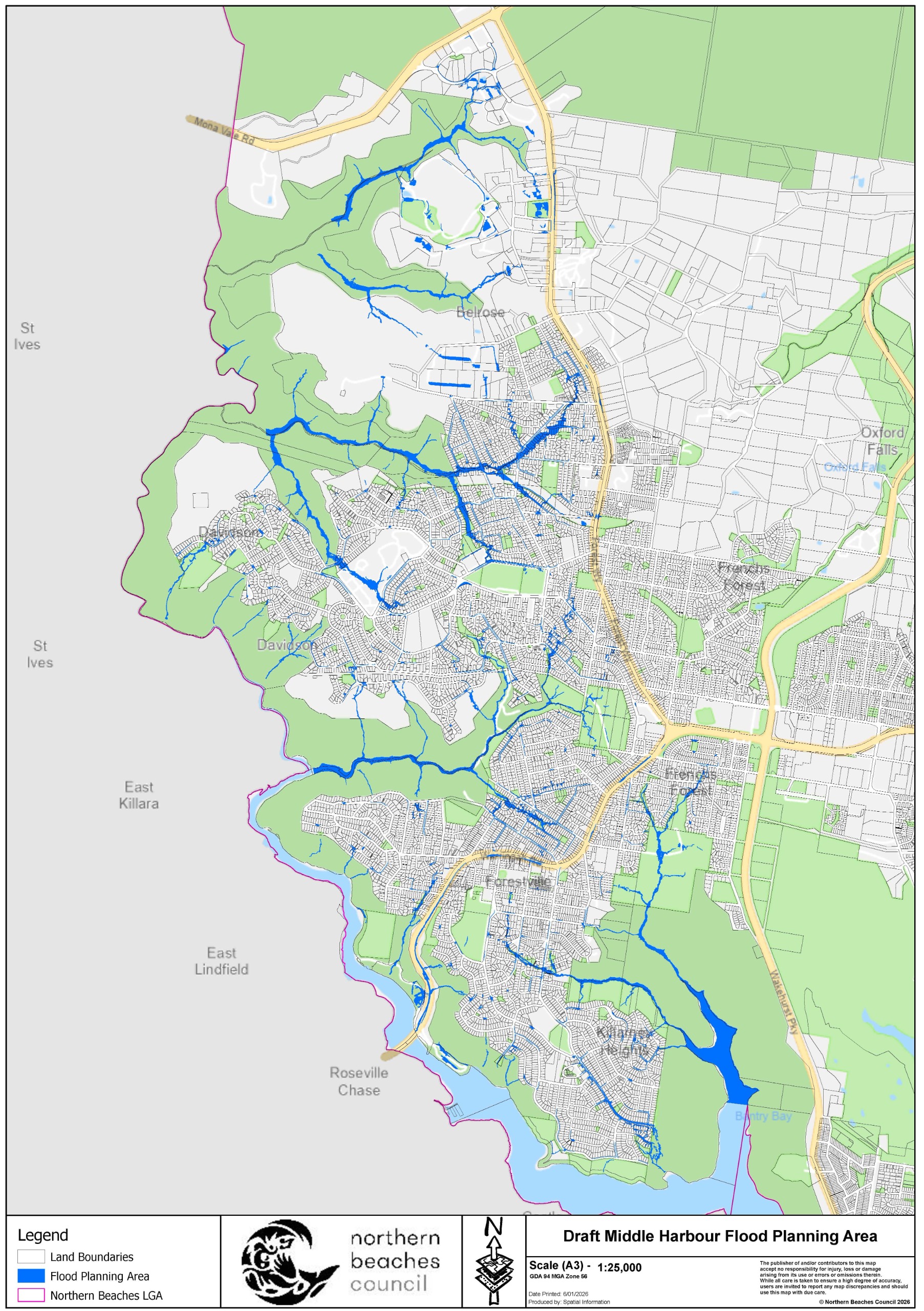
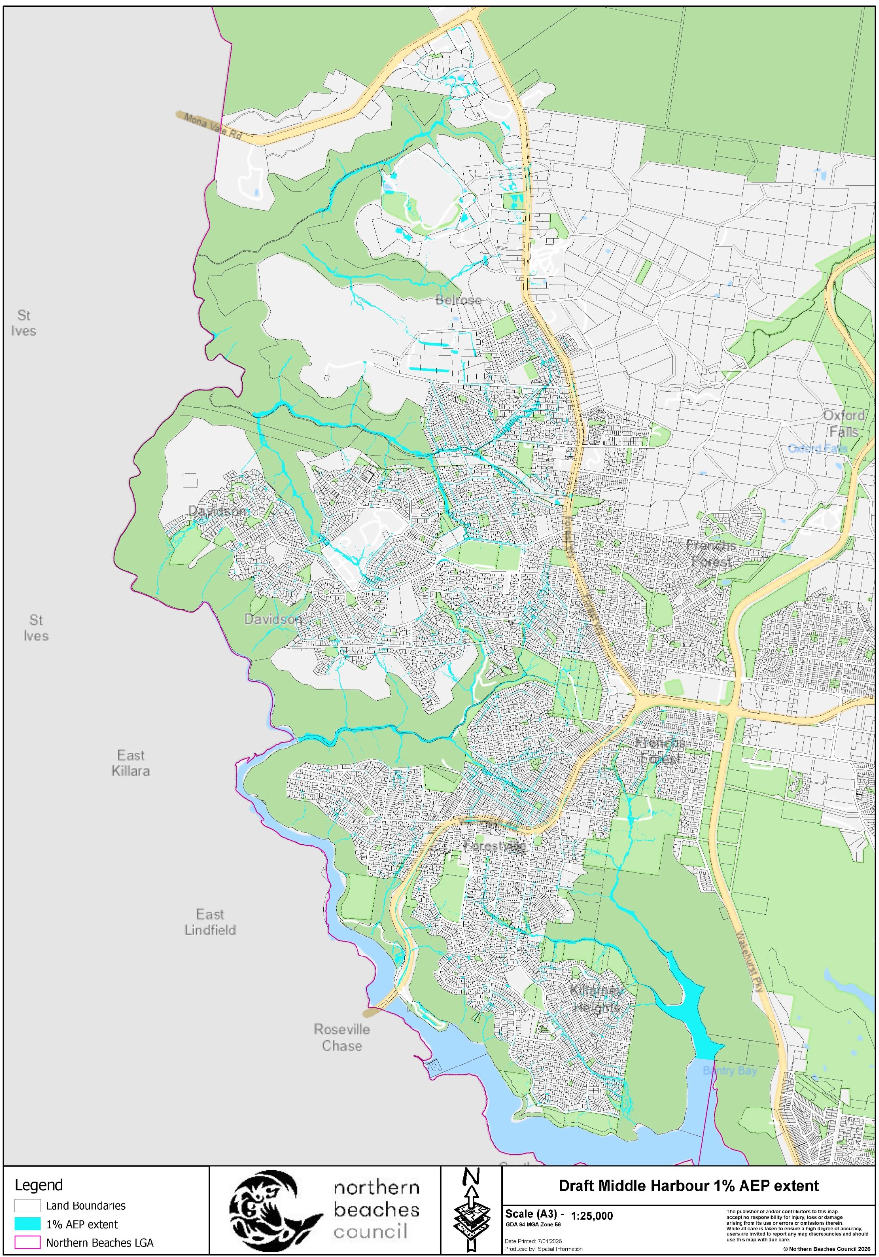
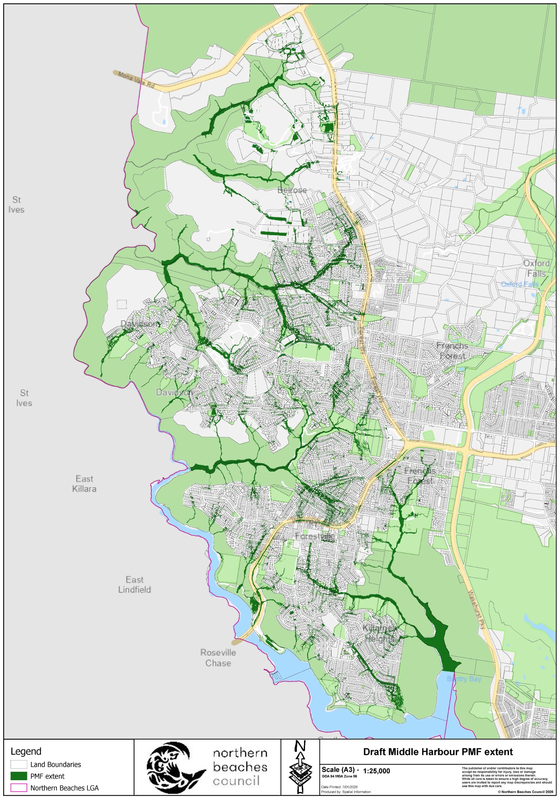
What's happening?
Identifying and managing flood risks
We are responsible for the identification of flood prone land in the Local Government Area. We also play a key role in the management of risks to life and property from flooding.
One of our most important activities is to increase our community's awareness of flooding so that people are better able to understand and plan for the flood risks they face.
A flood study aims to:
- define existing flood behaviour (including levels and extents)
- help identify flooding problem areas in the catchment
- assess the impacts of climate change.
We have prepared the draft Middle Harbour Flood Study (covering the areas of Belrose, Davidson, Frenchs Forest, Forestville and Killarney Heights) and it is now on public exhibition. The draft Study will guide future development, help emergency planning, and build a safer community.
Get involved
You can get involved by:
- reading the draft Flood Study report online through the tiles below or in hard copy at the Glen Street Library
- accessing the draft Flood maps available on the next tab, so you can be well informed on the potential impacts to your property
- discussing the results and what they mean for your property with Staff and the engineering consultants undertaking the study at one of the upcoming community information sessions at Glen Street Library - register online to attend a 15-minute individual session
- sharing knowledge to build capacity and resilience within our community
- providing your submission on the draft Flood Study over the next 4 weeks.
Download the draft Study by clicking on the tiles below
Flood maps
Working Group
Project Working Group
The purpose of the Middle Harbour Flood Study Project Working Group is to work with Council and provide feedback from a local perspective. The Working Group was established to provide a forum for discussion between the community, Council, State Government authorities and the Consultant undertaking the study.
The early stages of the project were reviewed by Council’s former Flood Management Committee, which was disbanded in February 2022. The Working Group will review the final stages of the project.
The first meeting was held on Wednesday 10 April 2024. There will likely be a total of 2 or 3 meetings.
Working group members
| Name | Representing |
|---|---|
James Ball | Community |
Christopher Brownlee | Community |
Paul Hackney | Community |
| Arthur Moreland | Community |
Barry Nolan | Community |
| John O'Brien | Community |
| Fiona Coe | Department of Climate Change, Energy, Environment and Water (DCCEEW) |
| Shelly Stingmore | NSW State Emergency Services (SES) |
| Valerie Tulk | Council - Senior Engineer – Floodplain Management |
| Charlotte McLoughlin | Council - Floodplain Management Officer |
Project history
What has happened so far
We have prepared a draft flood study to identify and map the overland flow paths in the catchments that drain into Middle Harbour. This helps with managing the flood risks in this area. The study area comprises parts of Belrose, Davidson, Frenchs Forest, Forestville and Killarney Heights.
Between 11 February 2022 and 27 March 2022, we asked the local community to help us better understand the flood behaviour in the catchment.
We invited you to share your experiences and knowledge of any flooding in the Middle Harbour catchments by completing our online survey. Of the 645 responses lodged, 193 residents indicated they had experienced flooding in the past. Thank you to everyone who provided feedback. You can view the outcomes of the engagement in the Draft Study documentation. Refer to Sections 3 and 6.3 of the report and for additional information outlining consultation responses see Table B1 and Figures 9 - 11 in the appendices.
This information was used by the Consultant in the preparation of the draft Flood Study, which is now on public exhibition until early March.
Resources
Document library
Project Working Group
-
 Middle Harbour Flood Study Consultant Presentation to PWG 10 April 2024PDF (5.62 MB)
 -
 Project Working Group Meeting Minutes - 10 April 2024PDF (121.48 KB)
How do Flood Studies impact insurances?
Council meeting links
-
Make a submission
Make your online submission and share your feedback on the draft Flood Study.
Alternatively, you can email or write to us. Please include 'Draft Middle Harbour Flood Study' in the subject line of all email or written feedback.
Have an enquiry or want to make a email/written submission?
| Name | Charlotte McLoughlin - Floodplain Management Officer |
|---|---|
| Phone | 1300 434 434 (during business hours) |
| floodplain@northernbeaches.nsw.gov.au | |
| In writing | 'Draft Middle Harbour Flood Study' Northern Beaches Council, PO Box 82, Manly NSW 1655. |
*The submission count is manually updated and only indicative until the final report is published. It reflects the total online contributions and in-person survey responses. Duplicate submissions will be counted as one unique submission.
**All submissions in their entirety are made publicly available in the Community Engagement Report. Personal identifying information, and content which is discriminatory, hateful or which may defame, offend, insult, humiliate or intimidate will be redacted.
Contact customer service on:
1300 434 434
We
acknowledge the Traditional Custodians and their Country on which we
gather today. By these words we show our respect to all Aboriginal
people. We acknowledge Elders past, present and emerging and the spirits
and ancestors of the Clans that lived in this area.
Connect with us on social media


