
Your Say Northern Beaches

Menu
  • Home
  • All Projects
  • Login
  • Sign up
  • Login / Join
  • My profile
    • Edit profile
    • Sign out
  • Search this site...

Middle Harbour Flood Study (draft)

Understanding flood risks in the area

You are here:

  1. Home
  2. Middle Harbour Flood Study (draft)
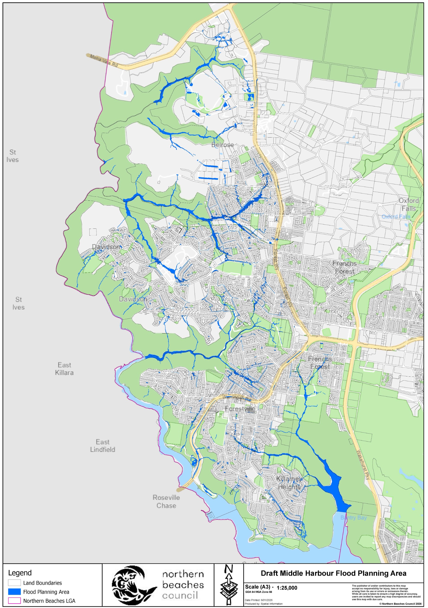
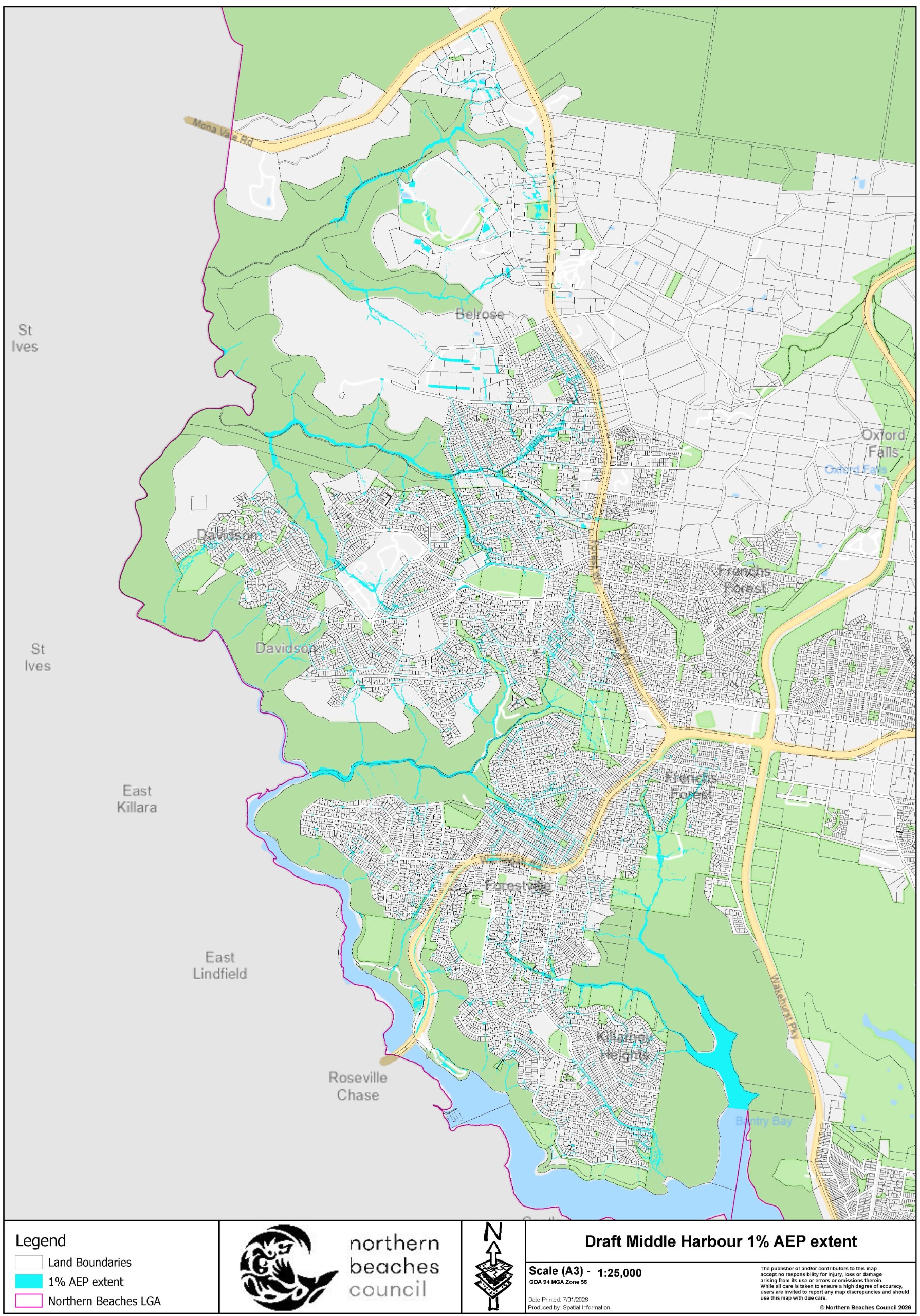
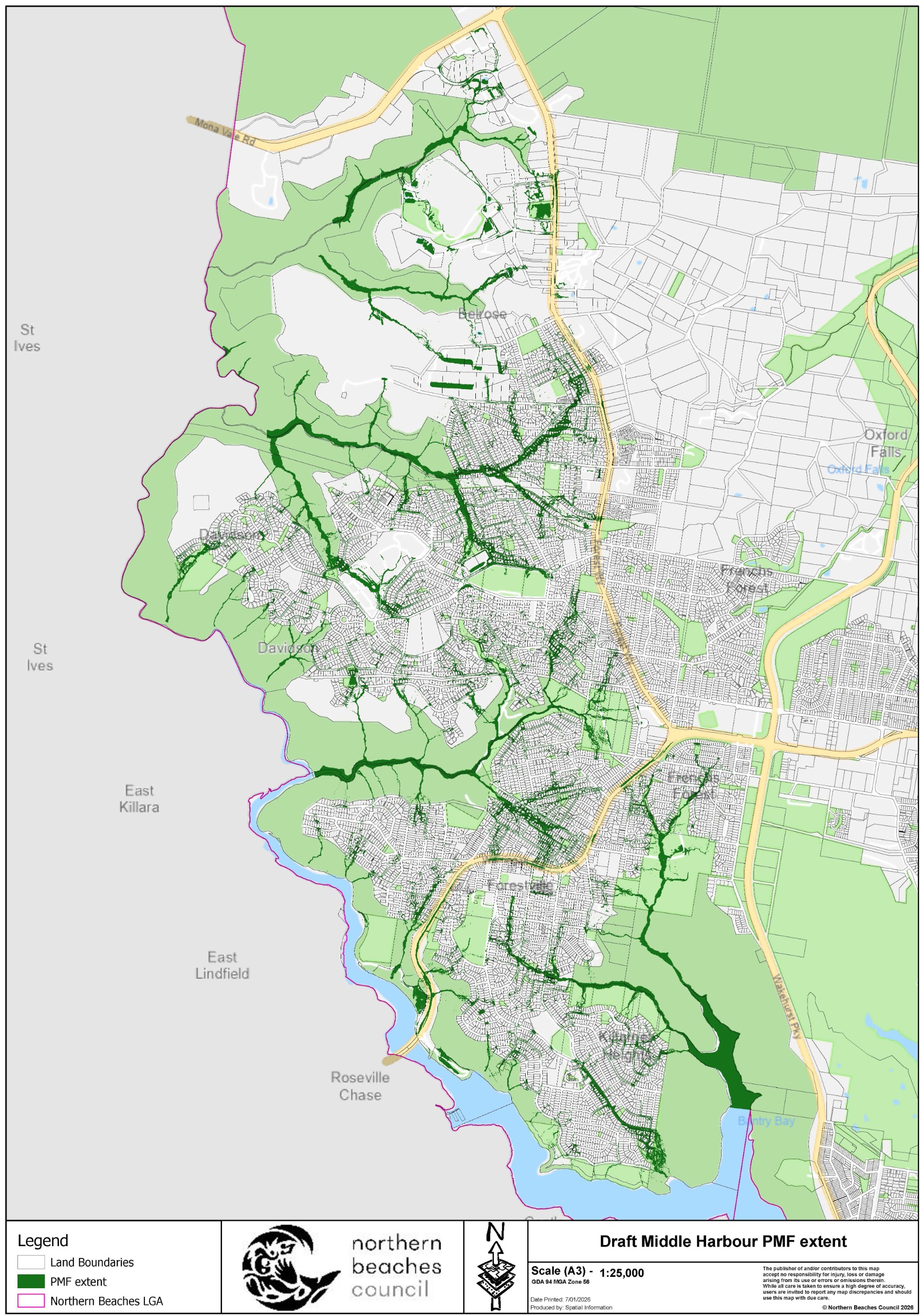
  • Reviewing your submissions

    We asked for your feedback on the draft Middle Harbour Flood Study (draft Study), thank you for your comments. The draft Study was exhibited for over 6 weeks and we received over 60 submissions. Submissions have been sent to the Consultant for review and we will be providing responses in due course.

What's happening?

Identifying and managing flood risks

We are responsible for the identification of flood prone land in the Local Government Area. We also play a key role in the management of risks to life and property from flooding.

One of our most important activities is to increase our community's awareness of flooding so that people are better able to understand and plan for the flood risks they face.

A flood study aims to:

  • define existing flood behaviour (including levels and extents)
  • help identify flooding problem areas in the catchment
  • assess the impacts of climate change.

We have prepared the draft Middle Harbour Flood Study (covering the areas of Belrose, Davidson, Frenchs Forest, Forestville and Killarney Heights). The draft Study will guide future development, help emergency planning, and build a safer community.

We sent letters to all owners of property affected by the flood study. Properties identified as flood affected are shown on the Flood maps tab.

We asked you to get involved by:

  • reading the draft Flood Study report online through the tiles below or in hard copy at the Glen Street Library
  • accessing the draft Flood maps available on the next tab, so you can be well informed on the potential impacts to your property
  • discussing the results and what they mean for your property with Staff and the engineering consultants undertaking the study
  • sharing knowledge to build capacity and resilience within our community
  • providing your submission on the draft Flood Study

Download the draft Study by clicking on the tiles below

  • Draft Study (main text)

  • Appendices (large document)

Map of the study area

Map of the study area

Flood maps

Image 1 of 3

Middle harbour flood planning map

Flood Planning Area

Middle harbour 1% Annual Exceedance Probability extent map

1% Annual Exceedance Probability (AEP) extent

Middle harbour PMF extent map

Probable Maximum Flood (PMF) extent

Working Group

Project Working Group

The purpose of the Middle Harbour Flood Study Project Working Group is to work with Council and provide feedback from a local perspective. The Working Group was established to provide a forum for discussion between the community, Council, State Government authorities and the Consultant undertaking the study.

The early stages of the project were reviewed by Council’s former Flood Management Committee, which was disbanded in February 2022. The Working Group will review the final stages of the project.

The first meeting was held on Wednesday 10 April 2024. There will likely be a total of 2 or 3 meetings.

The next meeting will be held in April 2026.

Working group members

NameRepresenting

James Ball

Community

Christopher Brownlee

Community

Paul Hackney

Community

Arthur MorelandCommunity

Barry Nolan

Community

John O'BrienCommunity
Fiona CoeDepartment of Climate Change, Energy, Environment and Water (DCCEEW)
Shelly StingmoreNSW State Emergency Services (SES)
Valerie TulkCouncil - Senior Engineer – Floodplain Management
Charlotte McLoughlinCouncil - Floodplain Management Officer
Download the meeting minutes open in new window

Project history

What has happened so far

We have prepared a draft flood study to identify and map the overland flow paths in the catchments that drain into Middle Harbour. This helps with managing the flood risks in this area. The study area comprises parts of Belrose, Davidson, Frenchs Forest, Forestville and Killarney Heights.

Between 11 February 2022 and 27 March 2022, we asked the local community to help us better understand the flood behaviour in the catchment.

We invited you to share your experiences and knowledge of any flooding in the Middle Harbour catchments by completing our online survey. Of the 645 responses lodged, 193 residents indicated they had experienced flooding in the past. Thank you to everyone who provided feedback. You can view the outcomes of the engagement in the Draft Study documentation. Refer to Sections 3 and 6.3 of the report and for additional information outlining consultation responses see Table B1 and Figures 9 - 11 in the appendices.

This information was used by the Consultant in the preparation of the draft Flood Study, which went on public exhibition from early February until the end of March 2026. Submissions are now being considered.

Resources

Document library

Project Working Group

  • Middle Harbour Flood Study Consultant Presentation to PWG 10 April 2024
    PDF (5.62 MB)
  • Project Working Group Meeting Minutes - 10 April 2024
    PDF (121.48 KB)

How do Flood Studies impact insurances?

  • Flood Data Requirements - Insurance Council Fact Sheet
    PDF (775.87 KB)
  • Flood Insurance Pricing - Insurance Council Fact Sheet
    PDF (840.10 KB)
  • Flood Insurance Risk Information - Insurance Council Fact Sheet
    PDF (167.85 KB)

Council meeting links

  • Council Minutes - 16 Dec 2025, Item 11.1, p.6)
  • Council Report - 16 Dec 2025 (Item 11.1, p.33)
  • Attachments Booklet - 16 Dec 2025 (Item 11.1, p.77)

Council meeting links

  • Council Minutes - 16 Dec 2025, Item 11.1, p.6)
  • Council Report - 16 Dec 2025 (Item 11.1, p.33)
  • Attachments Booklet - 16 Dec 2025 (Item 11.1, p.77)

Public exhibition closed

We held 3 days of meetings with the project team and spoke with many of you over the phone about how the draft Study might affect you.

Key Dates

Engagement timeline

  • Timeline item 1 - complete

    Feb - Mar 2022: Community survey

  • Timeline item 2 - complete

    Jan - Mar 2024: EOI for Project Working Group

  • Timeline item 3 - complete

    Mar 2024 - Late 2025

    Develop draft Middle Harbour Flood Study

  • Timeline item 4 - complete

    Dec 2025: Report to Council

    Council endorsed publicly exhibiting the Study in early 2026

  • Timeline item 5 - complete

    Feb - Mar 2026: Public exhibition of draft study

    6 Feb - 23 March: exhibition period

  • Timeline item 6 - active

    Mid-2026: Report to Council for adoption of study

    We are reviewing your feedback and then will prepare a report to Council for consideration

Register for project updates


Frequently asked questions

Why does Council undertake flood studies?
What areas are included in the Middle Harbour catchments?
Is this the first time that a flood study has been undertaken in this area?

Frequently asked questions

Why does Council undertake flood studies?

Councils in NSW have responsibility for identifying and then managing the risk to life and property from flooding, and must act in accordance with the NSW Flood Prone Land Policy. The Policy is contained in the NSW Government’s Flood Risk Management Manual, and aims to reduce the impact of flooding and flood liability on owners and occupiers of flood prone property.

One of the most important steps in this process is increasing our community’s awareness of flooding so that people are better able to understand and plan for the flood risks they face. Flood studies also enable Council to provide information to emergency services such as the SES and Police to assist with emergency response.

What areas are included in the Middle Harbour catchments?

The study area comprises parts of Belrose, Davidson, Frenchs Forest, Forestville and Killarney Heights.

Is this the first time that a flood study has been undertaken in this area?

The Frenchs Creek Flood Study was completed for the northern part of this study area in 2010. Since then, technology has improved and computer modelling has become more accurate. The Frenchs Creek Flood Study is one of Council’s oldest current flood studies and will be superseded by the Middle Harbour Flood Study. There has not previously been a formal flood study undertaken elsewhere in the study area.

What is the 1% Annual Exceedance Probability (AEP) event?

The Annual Exceedance Probability (AEP) is the chance of a flood of a given or larger size occurring in any one year, expressed as a percentage. The 1% AEP flood has a 1% or 1 in 100 chance of being reached or exceeded in any given year.

This does not mean that if a location floods one year, that it will be flood free for the next 99 years. Also, if it has not flooded for 99 years, it does not mean there will definitely be a flood the next year.

Some parts of Australia have received a couple of 1% AEP floods within a decade of each other, and flood events much larger than the 1% AEP flood can, and do, occur (such as the January 2011 flood in Toowoomba).

What is the Flood Planning Level (FPL)?

The Flood Planning Level (FPL) is defined as the 1% AEP flood level plus an appropriate freeboard. It is used for planning purposes, such as setting the height for floor levels in flood-prone areas. The Flood Planning Area (FPA) is the area of land below the FPL and is subject to flood-related development controls.

The FPL can be calculated as:

FPL = 1% AEP flood level + freeboard (typically 0.5m).

What is Freeboard?

Freeboard is included in the Flood Planning Level as a buffer, to account for factors such as wind, waves, unforeseen blockages, other localised hydraulic effects and uncertainties in the modelling and determination of flood levels. Freeboard is typically 0.5m above a flood level.

What does it mean if my property has been identified as being in the Flood Planning Area (FPA)?

For most people, no action is required other than to be aware of the flood risk on your block. However, property owners who are planning redevelopment of their property should be aware that the draft Study will update the information on flooding in the area, which Council may use in assessing development applications and in applying flood-related development controls.

What is a Probable Maximum Flood (PMF) event?

The Probable Maximum Flood (PMF) event is the largest flood that could conceivably occur at a particular location.

What does it mean if my property has been identified as being in a Probable Maximum Flood (PMF) area?

This event is predicted to be extremely rare, however vulnerable types of development such as hospitals and aged care facilities may need to plan for these events.

For standard residential and commercial developments there would be no flood related development controls.

Where can I get information about flood levels on my property?

To talk with someone at Council about flooding, you can email Council at floodplain@northernbeaches.nsw.gov.au or phone 1300 434 434.

If you need specific information on flooding for a particular property, you can request a Flood Information Report.

​My home is on a hill so why am I flood affected?

If there is significant rain at the top of the hill, the rain will run downhill through low-lying gullies, channels and surface depressions. The speed and depth of floodwaters may be less at the top of the catchment than further down the hill, but still be significant enough to pose a risk.

What is Council doing to manage flood risk?

Council prepares Flood Studies and Plans according to the NSW Government's Flood Risk Management Manual (2023), and implements associated recommendations with the financial and technical assistance of NSW Government through its Flood Prone Land Policy.

Development controls on buildings in a flood zone are an effective way of protecting life and properties from flood risk.

Additional ways that Council manages flooding in the area include installing and monitoring a flood warning network, raising flood awareness in the community, and opening lagoon entrances to lower water levels.

​How does Council plan future drainage upgrades?

Council maintains a capital works delivery program which is reviewed each year in line with Council’s Stormwater Asset Management Plan. Council prioritises stormwater infrastructure improvements based on the latest data, impact on the community, impact on the environment and cost benefit ratio to maximise the benefit to the whole community having regard to competing obligations and limited resources.

​What does Council do to reduce blockage of drainage, pipes and pits?

Council follows a regular maintenance program for reducing blockage of drainage, pipes and pits.

In addition, prior to large, forecasted rain events, Council cleans pipes and pits at known problem and hotspot areas. Council also uses street sweeper trucks to clean gutters. During storm events, pipes can become blocked with rubbish, leaves and branches. A drainage, cleaning and maintenance request can be made via Council’s website.

​What should I do in the event of a flood?

If it is a life-threatening situation call 000. Otherwise, the NSW State Emergency Service (SES) can be contacted on 132 500.

The SES website provides information on what to do during an emergency and how to plan and prepare for a flood.

Where can I find out about Council’s flood related development controls?

Flood related development controls in this area can be found in the Warringah Local Environment Plan (Clauses 5.21 and 5.22) and the Warringah Development Control Plan (Part E11), which can be viewed at https://www.northernbeaches.nsw.gov.au/planning-and-development/planning-controls.

Will this flood study affect my insurance premiums?

Councils in New South Wales have a legal responsibility for identifying flood behaviour. While insurance companies do get access to flood studies through the NSW Government, which provides funding for the studies, this information is generally supplemented by information from multiple other commercial and proprietary sources. With more accurate flood information, insurance premiums in flood affected areas may be lower than if insurers rely solely on their own risk assessments, which often adopt conservative assumptions.

Individual insurers assess flood risk differently and may consider property-specific information such as floor levels and building materials. A more resiliently built home would suffer less damage during a flood event.

The Insurance Council of Australia Factsheets on the Resources tab contain more detailed information.

How has climate change been considered?

The potential impacts of climate change have been considered as part of the study. To understand potential changes in flood behaviour due to increased intensity of rainfall, a range of very large flood events were modelled. This analysis showed that resulting flood levels are typically increased by approximately 0.2m to 0.3m on key overland flow paths. New overland flow paths form in several locations in these very large events.

Council has prepared this study with financial assistance from the NSW and Commonwealth Governments through the Natural Disaster Resilience Program.

Have an enquiry?

Contact Information
Name Charlotte McLoughlin - Floodplain Management Officer
Phone 1300 434 434 (during business hours)
Email floodplain@northernbeaches.nsw.gov.au
In writing

'Draft Middle Harbour Flood Study' Northern Beaches Council, PO Box 82, Manly NSW 1655.

*The submission count is manually updated and only indicative until the final report is published. It reflects the total online contributions and in-person survey responses. Duplicate submissions will be counted as one unique submission.


Contact customer service on:

1300 434 434

We acknowledge the Traditional Custodians and their Country on which we gather today. By these words we show our respect to all Aboriginal people. We acknowledge Elders past, present and emerging and the spirits and ancestors of the Clans that lived in this area.

Connect with us on social media

  • Facebook
  • X
  • LinkedIn
  • Youtube
  • Instagram

  • Privacy Policy
  • Terms of Use
  • Accessibility
  • Moderation
© 2026 Your Say Northern Beaches.    All rights reserved. Log In to Site Currently logged in as USERNAME. Sign Out
Social Point by Open Point logo

Privacy Policy

What this policy covers

We, Northern Beaches Council, take our privacy obligations seriously and we’ve created this privacy policy to explain how we treat your personal information collected on this website.

Personal information is information we hold which is identifiable as being about you. Supply is voluntary, however non-supply may prevent us from responding to your specific comments.

Our collection, use and disclosure of your personal information is regulated by the Information Protection Principles under the NSW Privacy and Personal Information Protection Act 1998. Collection, use and disclosure of your personal information by Social Pinpoint is regulated by the Australian Privacy Principles under the Privacy Act 1988. You can find more information about your privacy rights at the Privacy Commissioner's web site: http://www.oaic.gov.au.

This site is owned and operated by Northern Beaches Council using software licensed from Social Pinpoint. For details on how Northern Beaches Council collects and protects your personal information, refer to this Privacy Policy. For details of how Social Point, by Open Point, may access personal information, please refer to Open Point’s Privacy Policy.


What personal information we collect

Profile information

We collect information from you when you register to use this site. This includes your email address and additional demographic information as provided by you on the registration form.

Please note that you are able to browse any publicly accessible sections of this website completely anonymously without signing up.

Engagement information

The content you create as part of your interactions with this website. These can include responses to surveys, comments on discussion forums, or any of the other engagement opportunities available here.

Usage information

We collect information about your usage of the site, such as pages visited, documents downloaded, etc.

How we use the information we collect

We collect this information in order to:

• analyse and interpret it to help meet our objectives and obligations

• communicate information to you about engagement opportunities, events and other initiatives

• respond to enquiries and otherwise engage with stakeholders.


External links

Our website may contain links to other websites. Those links are provided for convenience and may not remain current or be maintained. We are not responsible for the privacy practices of linked websites, and we suggest you review the privacy policies of those websites before using them.


Security

Information is being collected by Northern Beaches Council and will be stored by Social Pinpoint, 1st Floor, 119-1215 Beaumont Street, Hamilton NSW 2303.

All Australian data, including backups, are hosted within Australia’s federal jurisdiction and are located in secure data facilities in Sydney only. Australian data is not situated or moved offshore to international servers.


Requesting access or correcting your personal information

Subject to applicable local laws and regulations, you may have some or all of the following rights with respect to your personal data:

• to access your personal data and to rectify any inaccuracies within that personal data

• to request for the erasure of your personal data residing with us

• to request your personal data in portable, machine-readable format

• to withdraw your consent to our processing of your personal data.

If you wish to contact us with a request relating to personal information, please use the contact details set out below and ensure you include your name and contact details. We may need to verify your identity before providing you with your personal information.

In some cases, we may be unable to provide you with access to all your personal information and where this occurs, we will explain why. We will deal with all requests for access to personal information within a reasonable timeframe.


Contact Us

For further information about our privacy policy and related information practices, or to access or correct your personal information, or make a complaint, please contact us on council@northernbeaches.nsw.gov.au


Terms of Use

Terms of Use

The following Terms and Conditions govern the use of Have your say (“the site”). The platform is owned and operated by us, Social Pinpoint Pty Ltd, on behalf of Northern Beaches Council.

By accessing and using this site, you are choosing to accept and comply with the Terms presented throughout this agreement as well as the Privacy Policy and Moderation Policy. These Terms apply to all visitors and users of this site. Linked sites, affiliated services or third party content or software have their own Terms that you must comply with. If you disagree with any of the Terms presented in this agreement, you may discontinue using the site immediately.

If you are under 18 years old, please ensure that your parent or guardian understands and accepts these Terms and Conditions (including the Privacy Policy and Moderation Policy).

What are the conditions with a user’s account?

While using the site, you must not violate any applicable laws and regulations. It is our duty to protect the confidentiality of content you provide on our site in accordance with our Privacy Policy. When you create an account with us, you must always provide us with accurate information. Failure to provide accurate information violates the Terms, which may result in immediate termination of your account on our service. You are responsible for protecting your own password you use for this site and for any activities done under that password. Unauthorised use of your password or account must be immediately reported to Social Pinpoint. In some cases, we or our agents may require access to your user accounts to respond to technical issues.

We are not responsible for the content on the site that has been provided by the users of the site. Any content posted by you is subject to the rules of our Moderation Policy. Your contribution to the site may be edited, removed or not published if we consider it inappropriate (refer to Moderation Policy). Contributors should also be aware that their posts may remain online indefinitely. Where practical, you may choose not to identify yourself, deal with us on an anonymous basis or use a pseudonym.

What does Social Pinpoint require from their users?

You must understand and agree that, without limitation:

  • all information, data, images and other materials are the sole responsibility of the person from whom the content originated;
  • you are prohibited from advertising or offering to sell or buy any goods and services
  • you cannot transmit Content that contains software viruses or programs designed to change or destroy the functionality of any computer software or hardware; or
  • you cannot collect or store personal data about other users of the site
  • you cannot impersonate any person or entity, including without limitation to a Social Pinpoint representative
  • you cannot interrupt or interfere with the site or servers or networks connected to the site
  • you cannot attempt to gain unauthorised access to the site or other use accounts
  • Can your account be suspended or terminated?

    We may terminate or suspend access to your site and/or account immediately, without prior notice, including without limitation if you breach the Terms. We may immediately deactivate or delete your account and all the related files and information in your account. After your account has been terminated, the content you have posted may also remain indefinitely on the site.

    If you want to terminate your own account, please send an email to info@socialpinpoint.com.

    Governing Law

    These Terms shall be governed in accordance with the laws of Victoria, Australia, without regards to its conflict of law provisions.

    Indemnification

    Social Pinpoint, its subsidiaries, affiliates, officers, agents, licensors and other partners are not responsible for any loss, liability, claim, or demand, including legal fees, made by any third party due to or arising from a breach of this agreement and/or any breach of your representations and warranties set forth above.

    What content does Social Pinpoint own?

    Your Say website contains the copyrighted material, trademarks, patents, trade secrets and other proprietary information (“Intellectual Property”) of Social Pinpoint and its suppliers and licensors. Social Pinpoint owns and retain all proprietary rights in the intellectual property. All intellectual property in the content of this site including without limitation to text, software, source code, pages, documents and online graphics, photographs, sounds, audio, video and other interactive features are owned by or licensed to us.

    Any original content that you submit or post on our site may be made available to the public and allows users to share your content (with the end user acknowledging your contribution) under the Creative Commons Attribution-ShareAlike 4.0 Australian License.

    Except for Intellectual Property which is in the public domain or for which you have been given written permission, you may not copy, alter, transmit, sell, distribute any of the Intellectual Property.

    We are not responsible for your communications or dealings, including payment and delivery of goods or services, with a third party found via our website. Any loss or damage incurred from those communications or dealings are solely between the user and the third party.

    Disclaimer and Warranties

    Users must agree that you use of the site is at your own risk. We make no warranty that the site will meet your requirements or be uninterrupted or error-free. Any material that the user downloads through the site is done at their own risk and are responsible for any damages to their computer system or loss of data.

    What happens if these Terms change?

    We reserve the right, at our sole discretion, to modify or replace these Terms at any time without notice. The most recent version of the Terms can be seen on this page. By continuing to access or use our site after those revisions become effective, you agree and will comply to the revised terms. If you do not agree to the revised terms, please discontinue using our site.

    Contact Us

    If you have any questions about these Terms, please contact us at info@socialpinpoint.com

    Welcome back

    OR

    Log in with email

    Forgot your password?

    Need an account? Sign up today

    Reset password

    Enter your email address below. We will send you instructions to reset your password.

    Back to Log in

    Join our online community to participate in shaping our future

    Creating an account helps us better understand your needs and the needs of the community.

    OR

    Sign up with email

    Your password must have a minimum length of 5 characters.
    By creating an account you agree to our Privacy Policy and Terms of Use

    Already have an account? Log in now

    Thank you, your account has been created.

    Thank you, your account has been created.

    User Details


    You’re using an outdated browser.
    Some features of this website may not work correctly. To get a better experience we strongly recommend you download a new browser for free:

    • Download Chrome
    • Download Firefox
    • Download Edge
    • Download Safari
    Follow CTA

    Thank you for your contribution

    Would you like to follow this project to receive email updates?

    No thanks