What's the latest?
Update - June 2024
Council has now finalised the Conservation Zones (C Zones) Review. This is based on final Department advice as well as extensive technical studies, community submissions, mapping accuracy review, and initial site visits.
Please keep up to date via the LEP/DCP project page.
The C Zones Review forms a critical component of the Planning Proposal for the creation of a new consolidated LEP for Northern Beaches. The outcomes from the Review has established rigorous and evidence-based methodology for conservation, residential, rural, and recreational land use zonings and permissible land uses across the whole LGA.
What are the outcomes from the Conservation Zones Review?
The methodology for conservation zoning has been revised following the public exhibition of the C Zones Review, final advice from the Department of Planning, Housing and Infrastructure, and further technical analysis.
The revised C Zones methodology entails a reduction in the total number of proposed rezonings compared to the exhibited methodology - this is mainly due to the removal of hazard criteria as triggers for a conservation zone, and the retention of existing conservation zoning throughout the LGA.
This has resolved the majority of disputed proposed rezonings, thereby reducing the need for further assessment or site visits. Independent reviews, potentially including site visits, will continue to be undertaken as required for any remaining disputed rezonings or for any disputed rezonings arising during the public exhibition of the LEP Planning Proposal.
The outcomes from the Conservation Zone Review are reported in the following documents
- -Agenda papers (including Planning Proposal) for the 17 June Extraordinary Council meeting
- -Appendix H - Conservation Zones Review - Outcomes and Implications
- -Appendix C-18 - Land Zoning Mapbook
An interactive map will be made available during the public exhibition to enable community members to easily review proposed property-based planning controls e.g. zoning map, at the individual property level, and any reasons for change.
What happens next?
The C Zones methodology and mapping has informed the preparation of the Planning Proposal for the creation of a new, consolidated LEP for the Northern Beaches.
The Planning Proposal will be reported to an Extraordinary Council Meeting on 17 June 2024.
If Council agrees, it will then be submitted to the Minister for Planning Public Places for ‘Gateway Determination’. These are legally required steps that must be undertaken before the Planning Proposal can be placed on public exhibition.
Dependent on the timing and nature of the Gateway Determination, it is anticipated that the Planning Proposal will be placed on public exhibition in early-to mid 2025.
To stay informed check out the Local Environmental Plan project page for updates. Visit the page and click +Follow to register for project updates.
Project updates
Since the completion of the public exhibition Council has been consulting the NSW Department of Planning and Environment (the Department) on the proposals as part of a special “pilot project”.
In late November 2023, Council received final advice from the Department about the project. Amongst other things, that advice directed Council to:
- retain existing conservation zoning throughout the Local Government Area, and
- remove natural hazard criteria (e.g. bushfire prone or flood prone land) and “Medium Environmental Value” criteria from the zoning methodology
Council is currently amending its Conservation Zones criteria and re-mapping the outcomes for further consideration.
Upon completion of this work and other work associated with Council’s new Local Environmental Plan (LEP), a report will be presented to Council (mid-2024) to endorse a Planning Proposal for submission to the Department for a ‘Gateway Determination’. The Planning Proposal and updated draft land use zoning maps will be placed on statutory public exhibition following endorsement by Council and the issue of a Gateway Determination by the Department.
This calendar year (2023), we have been finalising a draft of the new Northern Beaches Local Environmental Plan (LEP) and Development Control Plan (DCP) to provide our community with a clearer, simpler, and fairer set of planning rules.
This has included a series of meetings with the Department of Planning and Environment (DPE) on the Conservation Zones Review. We are currently waiting on written advice from DPE to finalise the Review methodology and other key aspects of the draft LEP.
In the interim, we commenced a program of engagement with the Councillors to discuss proposed LEP content based on the community feedback we have already received.
In 2024, we aim to report to Council a draft LEP for submission to DPE for approval, also referred to as ‘Gateway Determination’.
Once we receive the Gateway Determination, we will prepare the LEP for public exhibition together with a draft DCP. The exact timing of reports to Council and public exhibition relies upon the receipt of final written advice from DPE, the timing of the Gateway Determination from DPE, and the interrelationship of these key decisions with the timing of Local Government Elections (September 2024).
You can view the project timeline at the end of our ‘Planning our Sustainable Future’ webpage.
Pilot Project with Department of Planning and Environment (DPE)
We have completed a series of meetings with the Department of Planning and Environment (DPE) as part of a ‘Pilot Project’ and now we are awaiting their formal advice which we are expecting in early September.
This advice may result in changes to the Conservation Zones Review methodology depending on DPE’s final views on each of the environment and hazard criteria proposed for use in the methodology (see draft methodology).
Once we receive this advice, we will prepare updated mapping of relevant criteria and review the outcomes against previous community submissions to determine the impacts. We anticipate that this process will in many cases resolve the concerns raised in these submissions.
Site Investigations
As resolved at Council’s meeting 23 August 2022, we will undertake an independent review, including a site inspection, where there remains a dispute about rezoning of land under the Review. These independent reviews cannot commence until we receive the DPE advice, re-runs the maps and reviews the impacts on land that may be the subject of a dispute.
Impact on the LEP/DCP Process
The Conservation Zones Pilot Project has resulted in delays to the LEP/DCP Program. Consequently, the updated methodology for the Conservation Zones Review is likely to finalised by late 2023 and the draft LEP/DCP will now go to Council in 2024, with the statutory public exhibition expected in late 2024/early 2025.
Pilot Project with Department of Planning and Environment (DPE)
Earlier in March, Council met with the Department of Planning and Environment (DPE) to discuss a Pilot Project to further investigate the methodology and mapping used in our Conservation Zones Review and to explore potential changes to address community and stakeholder feedback.
This is important because the Department will have the final say about any proposed zoning changes resulting from the Review.
Site visit requests and mapping Investigations
We have also undertaken a review of all the submissions to the public exhibition. This has shown:
- Over three hundred submissions raised concerns with the accuracy of mapping, including approximately fifty which requested a site visit.
- Approximately forty submissions requested a site visit based on their concerns about the methodology.
We are conducting a desktop/ online assessment of those submissions which raised issues with mapping accuracy. This work will continue over the next few months concurrently with the Department of Planning and Environment Pilot Program.
Once we reach agreement with the Department of Planning and Environment on a revised methodology, site inspections will be arranged for landowners whose submissions on mapping have not been resolved.
Due to the timing of the Pilot Project with the Department, site visits may not now commence until July/August. We will contact those who requested a site visit to notify them of the delay.
Whilst Council is considering changes to its methodology to address submissions received, it does not propose to conduct site visits where a submission requests one based on methodology, as specific site conditions will not impact methodology.
We are aiming to complete all relevant work by early September.
The outcomes from the Review will help us develop a draft Northern Beaches Local Environmental Plan and Development Control Plan, which will be presented to Council and exhibited for community feedback in 2024.
We will continue to keep you updated.
We anticipate many of the issues raised can be resolved by potential changes to the draft methodology which Council is currently investigating.
Where areas of dispute remain about the accuracy of Council mapping of criteria used in the review, we will engage relevant consultants and contact those landowners who have requested a site inspection.
We are expecting to commence site visits from May 2023.
We are also meeting with the Department of Planning and Environment to discuss the Review, the submissions received, and possible changes. This is important because the Department will have the final say about any proposed zoning changes resulting from the Review.
The outcomes from the Review will help us develop a draft Northern Beaches Local Environmental Plan and Development Control Plan, which will be presented to Council and exhibited for community feedback in 2024.
We will continue to keep you updated.
The Review
Read the Conservation Zones Review
-
Executive Summary Conservation Zones Review
Draft Conservation Zones Review
Outcomes
Consultation outcomes
We have reviewed all 935 submissions received in response to the public exhibition of the Conservation Zones Review and Technical Studies.
The main aim of this exhibition was to seek feedback on a draft methodology for the use of Conservation Zones across the Northern Beaches.
You can read the Consultation Report below which summarises the key issues and Council’s response to this feedback. You can also view the redacted submissions received through the public exhibition.
-
Snapshot Consultation Report
A brief summary of the engagement approach and issues raised in the submissions
Consultation Report
The detailed Community Engagement and Stakeholder Consultation Report
Submissions
(Updated 30 March 2023) The file may take some time to load due to size (approx. 300mb). Personal details and inappropriate language have been redacted where possible. Read our privacy policy for more information.
Engagement history
Engagement history
We are reviewing how we apply conservation zones in our current Local Environment Plans (LEPs) to create a consistent approach to their use in the new Northern Beaches LEP.
This review is the next step of Planning Our Sustainable Future and moving towards developing a single planning framework for the Northern Beaches, as required by the NSW government.
Watch the video to get an overview of the project.
Conservation zones are applied to land with environmental values or where there are significant hazards such as bushfire. The review is investigating which land areas should be included in conservation zones and what development should be permitted in these areas.
We are proposing zoning changes that may affect what you can and cannot do on your property.
Use our online search tool to find out how it may affect you.
We want to make sure we are applying the right zoning to the right area using the best available knowledge.
- Are we using the right criteria for a particular conservation zone?
- Are we applying the criteria to the right percentage of land?
We know this is a complex process, so to help you navigate the information, we have a range of tools to assist, including:
- Webinar recordings and presentations
- Frequently asked questions (FAQ)
- We've also added an Easy Read version to the Executive Summary and the full Draft Conservation Zones Review.
If you have more questions or need support with the online search tool, call our team of planners who are happy to help.
Call the Strategic and Place Planning Team on 1300 434 434 or email us
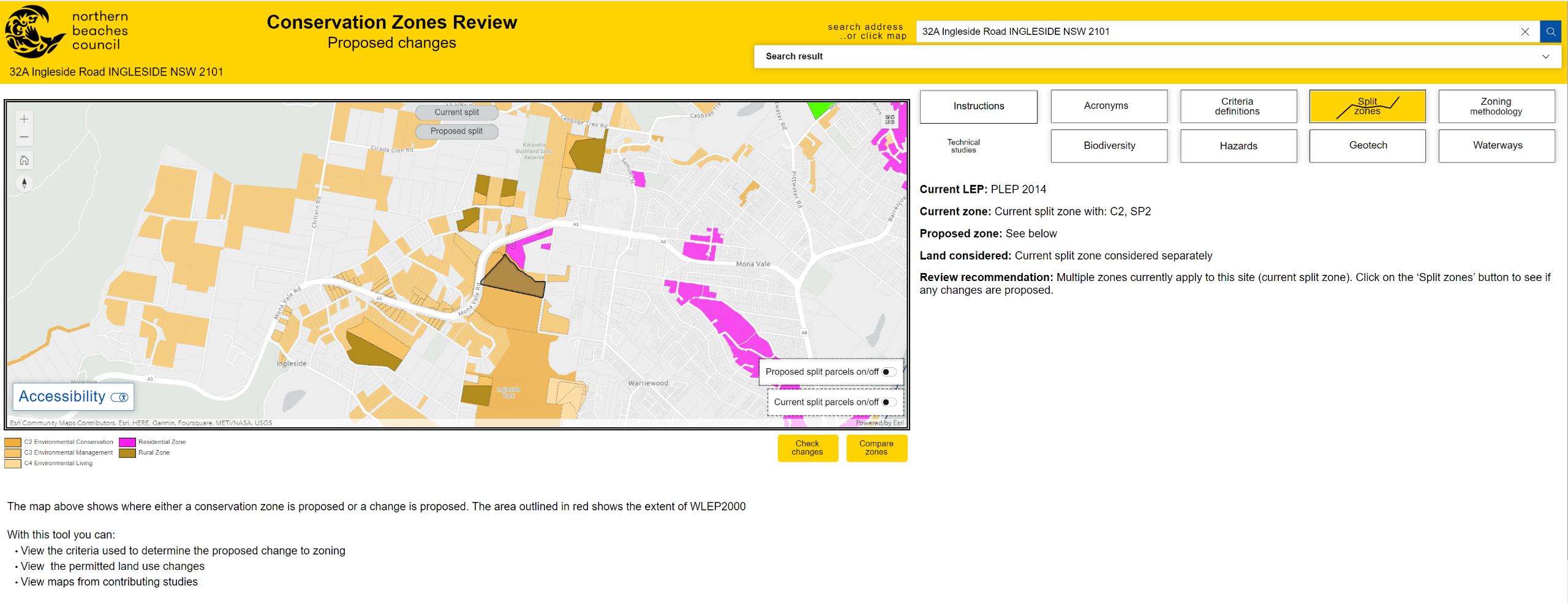
Property search
What could it mean for you?
Use our online search tool to find out
This is the first stage in the conservation review process and to find out how this may or may not affect you.
Simply, click on the above blue button to go to our online search tool, enter and select your address, or click on the map, to see:
- The current and proposed zone, any criteria identified on the site and any thresholds such as the % cover (if relevant)
- The process undertaken (Zoning Methodology) and criteria used (Criteria Definitions)
- Any changes in permitted land uses (scroll down or select ‘Check changes’)
- A comparison of the current and proposed zones (select ‘Compare zones’)
- Recommendations for any zones that currently have more than one zone on site (select ‘Split zones’)
- Maps from the many Technical Studies also on exhibition (select any of the buttons for: Biodiversity, Hazards, Geotech and Waterways)
For the best experience use a larger screen, like a laptop or desktop (i.e. 1200 pixels).
See how the technical studies informed the review
Our Conservation Zones Review has been informed by a series of technical studies that identify areas with environmental value and significant environmental hazards.
You can find out more about each of the technical studies by clicking on the boxes below.
-
Biodiversity Assessment of Deferred lands
Biodiversity Planning Review
Cowan Creek Estuarine Planning Levels Study
Deferred Lands Strategic Bushfire Assessment
Geotechnical Review and Planning Controls
North & Middle Harbour Estuary Planning Study
Watercourse Wetlands & Riparian Study

Contact customer service on:
1300 434 434
We acknowledge the Traditional Custodians and their Country on which we gather today. By these words we show our respect to all Aboriginal people. We acknowledge Elders past, present and emerging and the spirits and ancestors of the Clans that lived in this area.
Connect with us on social media


